
FOIATONDA | COMMUNITY COOPERATIVE
GPX TRACKS AND TRAILS
Discover and download the GPX tracks of the main routes crossing our area.
“Living roots, strong communities, authentic mountain”
Paths through nature, spirituality, and adventure to be experienced step by step
GPX TRACKS | APPENNINE TRAILS
Page dedicated to the GPX tracks of the walks and trails crossing the Tuscan-Emilian Apennines: unique routes where nature, history and spirituality come together.
Whether you are a pilgrim, a walker, or an outdoor enthusiast, here you will find the GPX files to guide you along itineraries such as the Via Mater Dei, the walk dedicated to the Marian Sanctuaries of the Bolognese Apennines — a 157 km route through ridges, villages and spirituality; or you can explore the trails of the SBVS Outdoor project, created to enhance the walking network of the Municipality of San Benedetto Val di Sambro, featuring comprehensive mapping and a new walking map.
Download the tracks, prepare yourself, and let yourself be guided on an authentic journey through breathtaking landscapes, unexpected encounters, and a deep connection with the local area.
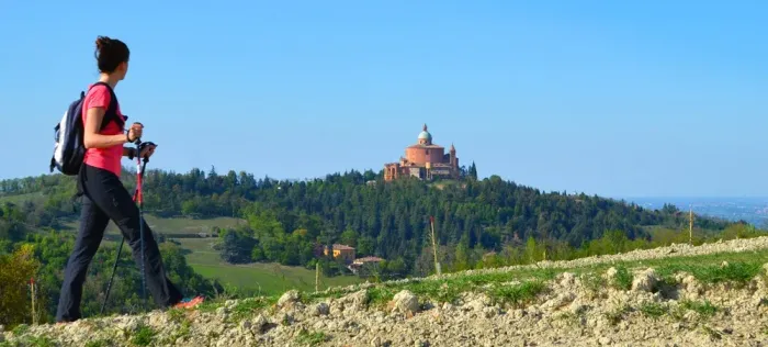
Via Mater Dei
The Via Mater Dei is the walk dedicated to the Marian Sanctuaries of the Bolognese Apennines.
It is a route of approximately 157 km, developed over seven stages along mid-mountain ridges, connecting the city of Bologna to 10 municipalities of the Bolognese Apennines: Pianoro, Monterenzio, Loiano, Monghidoro, San Benedetto Val di Sambro, Castiglione dei Pepoli, Camugnano, Grizzana Morandi, Vergato, and the municipality of Firenzuola, in the Tuscan territory.
Whether your culture is secular or religious, these will be days of great discoveries. It will be a journey of effort, of stumbles, of encounters, of imperfections, of limits that will become, time after time, springboards to continue with even more confidence towards the highest aspiration of every person: to become better.
Between faith and legends, between history and popular tales, this journey will reveal the deep bond that links Bologna to its mountains and to its communities, characterised by authenticity and generous, simple hospitality, which for centuries have protected and cared for the places of faith in the Apennines. This path will first win over the eyes, and then the hearts, of modern pilgrims who wish to undertake this journey.
Via Degli Dei
A walk between Bologna and Florence, through nature, history and a spirit of adventure
The Via degli Dei is a scenic route on foot or by bike that connects Bologna to Florence, crossing the Tuscan-Emilian Apennines. Along the way, you encounter ancient Roman roads such as the Flaminia Militare, the Contrafforte Pliocenic nature reserve, villages, castles, and spiritual sites like the sanctuary of Monte Senario.
Born from the playful spirit of a group of Bolognese walkers, the Via combines history, nature and culture, also passing through places marked by the Gothic Line during the Second World War.
Today, it represents a symbol of rebirth for the small communities of the Apennines and an example of sustainable tourism, where the journey matters as much as the destination.
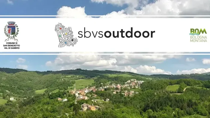
SBVS Outdoor
Project for the enhancement of the trail network of the Municipality
of San Benedetto Val di Sambro
The Municipality, aware of the importance of enhancing and enjoying its natural heritage, has recently completed a significant mapping project of the entire main trail network present in the area.
This effort resulted in the creation of the first Hiking Map of the Municipality, a valuable tool designed for residents, visitors, and hiking enthusiasts, useful for promoting mindful and respectful enjoyment of the environment.
GREEN
Anello delle Lame
Length: 14.7 km
Elevation gain: 529 m
Estimated duration: 4.5 hours
BLUE
Anello delle Sorgenti
Length: 14.1 km
Elevation gain: 620 m
Estimated duration: 4 hours
BLACK
Anello delle Sorgenti
Length: 16.4 km
Elevation gain: 688 m
Estimated duration: 4.5 hours
YELLOW
Anello dei Mulini
Length: 19.3 km
Elevation gain: 737 m
Estimated duration: 5.5 hours
RED
Anello dei Castelli
Length: 11.4 km
Elevation gain: 402 m
Estimated duration: 3.5 hours